Students can Download 1st PUC Geography Previous Year Question Paper March 2015 (South), Karnataka 1st PUC Geography Model Question Papers with Answers helps you to revise the complete Karnataka State Board Syllabus and score more marks in your examinations.
Karnataka 1st PUC Geography Previous Year Question Paper March 2015 (South)
Time: 3 Hrs 15 Min
Max. Marks: 100
Instructions:
- Answer All the questions.
- Draw map and diagrams wherever necessary.
- Question No. V is on cartography
- Blind students attempt only VA, 52, 53 and 54 instead of V – B, C and D.
I. Answer the following questions in a sentences each: (1 × 10 = 10)
Question 1.
What is modern Geography?
Answer:
It deals with ‘Earth and its inhabitants’.
Question 2.
What is the shape of the Earth?
Answer:
The shape of the earth is ‘Oblate spheriod’ or ‘Geoid’.
Question 3.
Name any two factors of Mechanical weathering.
Answer:
Temperature, Rainfall, Wind, Ice.
Question 4.
What is Atmoshpere
Answer:
The thin layer of gaseous matter encircling the earth in the form of blanket is known as Atmosphere.
Question 5.
Which instrument is used to measure depth of the ocean?
Answer:
Fathamometer.
![]()
Question 6.
Mention the types of currents.
Answer:
- Warm Current
- Cold Current
Question 7.
What is Environment?
Answer:
The study of surrounding of man lives and works.
Question 8.
What is the total geographical area of India?
Answer:
The total geographical area of India is 32,87,263 sq. km.
Question 9.
Name the longest coastal plains of India.
Answer:
The Gujarat coastline.
Question 10.
What type of climate is found in India?
Answer:
India has tropical monsoon type of climate.
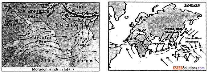
II. Answer any Ten of the following questions in 2 to 3 sentences each: (2 × 10 = 20)
Question 11.
Expand SIAL and SIMA.
Answer:
SIAL-Silica Aluminum SIMA-Silica Magnesium
Question 12.
Mention any two types of chemical weathering.
Answer:
- Oxidation
- Carbonation
Question 13.
State the difference between Endogenic and Exogenic forces.
Answer:
The internal forces are called endogenic forces. These are mainly the land building forces. The external forces are called exogenic forces. These are found on the surface of the earth.
Question 14.
Mention any two components of Atmosphere.
Answer:
- Various gases
- Water vapour.
Question 15.
Name the two important trade winds.
Answer:
- North east trade winds
- South east trade winds
Question 16.
What is weather and climate?
Answer:
Weather: Frequent variation in the atmospheric condition can be called weather force. For Example: Changes taking place in a day.
Climate: Long term variation in the atmospheric condition can be called climate. For example: Seasons.
Question 17.
Mention any four dissolved minerals in the ocean water.
Answer:
- Sodium chloride
- Magnesium chloride
- Magnesium Sulphate
- Calcium Sulphate
![]()
Question 18.
Mention any four uses of tides.
Answer:
- Tides helps fishing and other aquaculture activities.
- Tides promote salt production in the coastal areas.
- Tides promote the generation of tidal energy
- Tidal clean the entrance points, harbours and river mouths.
Question 19.
Write the latitudinal and longitudinal extent of India.
Answer:
8°4′ North to 37°6′ North latitude.
68°7′ East to 97°25! east longitude.
Question 20.
State the Neighbouring countries of India.
Answer:
- Pakistan and Afghanistan in the Northwest.
- China, Nepal and Bhutan in the North.
- Myanmar in the west, Bangladesh in the Northeast.
- Srilanka and Maldives are in the South Oceanic Zone.
Question 21.
Name any two hill stations of the Himalayas.
Answer:
- Shimla
- Mussorie
- Darjeling
- Nainital
Question 22.
Mention any four west flowing rivers of peninsular India.
Answer:
- The Luni
- The Sabarmati
- The Narmada
- The Sharavathi
III. Answer any Eight of the following questions in 25 to 30 sentences each: (5 × 8 = 40)
Question 23.
Explain the important branches of Geography.
Answer:
1. Physical Geography.
The field of physical geography is wide as it includes the study of the entire surface of the earth and also its physical and biological process as well as their morphology. Modern geography has witnessed the development of many branches and some of them even grown into separate disciplines.
Some of the important branches of physical geography are as follows:
- Geomorphology: It is a systematic study of landforms, such as mountains, plateaus, plains, valleys, etc.
- Climatology: Climatology encompasses the study of structure of atmosphere and elements of climates and climatic types and regions.
- Meteorology: The scientific study of atmosphere condition is called meteorology.
- Pedology: It is the scientific study of soil formation, structure, texture, chemical composition and their influence on plant growth.
- Hydrology: Hydrology studies the realm of water over the surface of the earth including oceans, lakes, rivers and other water bodies and its effect on different life.
- Seismology: It is the study of Earthquakes, their effects and distribution.
- Astronomical Geography: It is the study of heavenly bodies of the space like planets, satellites, stars etc in relation to the earth.
- Volcanology: It is the scientific study of tectonic process of volcanoes.
- Astronomical geography: It is the study of heavenly bodies of the space like planets, satellites, stars etc in relation to the earth.
- Bio-geography: It is the systematic study of the distribution of plants and animals.
- Hydrology: The study of water on the earth’s land is known as hydrology.
- Oceanography: The study of waves, tides and currents and the other characteristics of oceans, known as oceanography.
2. Human geography: It deals with man and his activities particularly cultural environment factors on man made factors, Important among them are culture, Society, agriculture, mining, industry, transport forming trade population etc.
Some of the important grander of Human geography are as fallows:
1. Political geography: It deals with spatial unit, people distribution, political behavior, political divisions etc.
2. Economic geography: It refers to basic attributes of the economy such as production, distribution exchange of goods and consumption. It deals with the spatial aspects of production, distribution and consumption and also helps on understanding the most proper location for establishing different human activities.
3. Commercial Geography: It deals with the spatial distribution of trade and commercial practices etc.
4. Population Geography: It helps to understand the distribution, growth density, migration and various other components of population.
![]()
Question 24.
Name and explain the proofs in support of the spherical shape of the Earth.
Answer:
There are several proofs to regard the earth as a spherical shape of the Earth.
a. Heavenly bodies appear to be spherical: The Sun, the Moon and other heavenly bodies appear to be spherical when viewed from different position. The earth is one of them and hence it must also be spherical in shape.
b. The Lunar Eclipse: The lunar eclipse proves that the Earth is in spherical shape. During lunar eclipse when the Earth is between the Sun and the Moon, the shadow of the Earth falls on the Moon. Aristotle was the first scholar to show this by looking at the shadow of the Earth on the lunar surface. Later, this was ascertained by Ptolemy. This is considered to be the oldest proof in respect of the shape of the Earth.
c. Sunrise and Sunset: The time of Sunrise and Sunset is not the same everywhere in the world. This is due to spherical shape of the Earth. If the Earth were to be flat all places on the Earth would have had sunrise and sunset at the same time everywhere in the world.
d. Circumnavigation: Circumnavigation of the world can only be possible when the Earth is in spherical shape. If one start on a sea voyage towards the east, by moving constantly in the same direction, he would be able to complete a circle of the world and reach the original point form where he had started.
e. The Bed Ford level experiment: Dr.Alfred Russel Wallace conducted an experiment in 1956, along the Bed Ford level canal area in Britain. It is the most convincing proof of the curvature of the Earth. He fixed three poles of same height at an interval of about mile apart and observed through a telescope. It was found that the pole in the middle was higher than other two poles. It is due to the curvature of the Earth. If the Earth were to be flat all the poles would have the same horizontal level.
f. Sighting a ship: A ship on the sea approaching the coast, when seen from the short does not come into view all at once. The observer first sees the mast and then the hull and finally the whole ship. A ship moving away from the coast disappears gradually and finally out of view. If the Earth were to be flat the whole ship would have come into view.
g. Aerial and Satellite Photographs: The photographs taken by the cosmonauts in the recent decades and satellites have provided ample proof to show that the earth is spherical in shape.
Question 25.
Explain the effects of the rotation of the Earth.
Answer:
Rotation of the Earth causes various effects. They are:
a. Day and night caused by the rotation of the earth on its axis. This is because parts of the earth which face the sun have day and the parts which do not face the sun have night. This happen with precision and progression and not suddenly – The time when the sun beings to cast its light in the sky is known as dawn. At noon. The sun is overhead. At dusk, it is twilight and the sun is seen disappearing in the sky. At night, it is completely dark.
b. The duration of the day and night is not equal at all places on the earth because of the inclined axis. The length of days varies with respect to the seasons as well as latitude
c. The sun, the moon and the stars seem to move from east to west. This is because the earth spins from west to east. This effect is similar to what one experiences while looking at trees from a moving train.
d. The speed of rotation has created a centrifugal force resulting in a bulge in the middle portion of the earth and flattened top at the poles.
e. The earth’s rotation affects the movement of water in the oceans. The tides are deflected because of the rotation of the earth.
f. Rotation causes difference in time over various places on the earth.
g. The Earth acts as huge magnet: The one end of the needle of the compass always points towards the north magnetic pole. That means, the earth acts as a magnet. The rotation . of the earth causes the earth to act as a magnet.
h. Rotation of the Earth influences the movement of ocean water, particularly ocean currents.
i. The rise and fall in the sea level is called tides. Rotation of the Earth causes the lacing of water bodies to the Moon. The gravitational attraction of the Moon and position of the water bodies cause tides. This is a regular phenomenon due to Earth’s rotation.
Question 26.
Explain the structure of the Atmosphere.
Answer:
The distribution of temperature is not uniform at different height of the atmosphere. Along with the variation of temperature there are unique features at different heights. Based on these characteristics atmosphere is divided into four parallel zones.
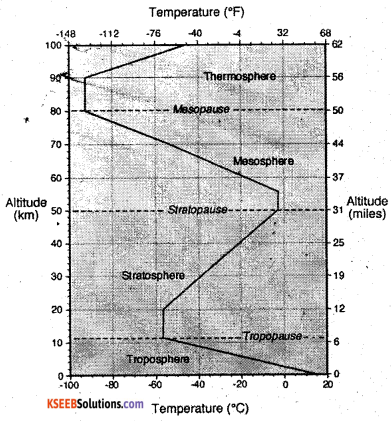
1. Troposphere: It is the lowest layer of the atmosphere and less closer to the earth. The word ‘Tropos’ means ‘turn’ It extends up to 18km at the equator and 8km at poles. Thus the average height is about 10-12km. The important feature of the troposphere are:
Hydrological cycle: It is confined to troposphere. The water evaporates and raised up, formation of clouds takes place. Later it is precipitated in various forms like rain, snow and hailstone. These processes are known as evaporation, condensation and precipitation.
Lapse rate: In this layer the temperature decreases at the rate of 6,5’ Celsius per every 1000 meters of height which is known as ‘lapse rate’.
Clouds: It is characterized with formation of clouds, thunder storms and lighting.
Gaseous Mass: The troposphere has about 75 percent of the total gaseous mass, The upper part of troposphere is known ‘Tropopause’.
2. Stratosphere: It lies above the troposphere and extends up to 50km from the earth. The temperature is also most uniformly distributed. Hence it also known as isothermal zone. At a height of 22kms. There is a thin layer of ozone which absorbs ultraviolet rays of the sun. So it is called as ozonosphere. The name staratopause is given to the upper part of the stratosphere.
3. Mesosphere: It extends from 50 to 80kms. It is an intermediary zone between the lower and upper layers of the atmosphere. A thin layer of air separating mesosphere from the other upper layers in named as‘Mesopause’.
4. Ionosphere: It extends from 90 to 500km. It consists of atoms of air ionized due to intensive temperature. So it is also known as ionosphere or Thermosphere. The radio waves of different length are reflected back from this layer.
5. Exosphere: The region beyond the Thermosphere is called Exosphere. It extends to about 1,000 km and the gravity of the Earth’s too weak in this layer. Magnetosphere is found above this layer. Atmospheric layer in between 500-700kms is known as Exosphere and the atmosphere lying beyond is called‘Magnetosphere’.
![]()
Question 27.
What is Rainfall? Explain the types of rainfall.
Answer:
Rainfall is the natural process of condensation through which gaseous form of water is converted into liquid water droplets. It occurs due to cooling of saturated air mass, warm and moist air mass rising upward, warm air rising over cold air, sufficient humidity in the air and condensation. Rain fall is classified on the basis of condition and mechanism of upward rise of air and its cooling. Therefore, there are three types rainfall. They are explained as follows:
1. Convectional Rainfall: Earth surface is heated by the solar radiation. Due to this the warm moisture-laden air becomes light and ascends upwards vertically and quickly. The warm and moist air cools below dew point and condensation takes place rapidly, and dense clouds are formed. This led to the heavy rain fall with thunder and lighting. For convectional rainfall, there is need for local heating which leads to excessive evaporation.
There should not be any strong winds to lesser the heat such a condition of great heat, excessive evaporation and stagnant air is found in the equatorial regions through out the year As such, the convectional rainfall occurs in the daily afternoon in the equatorial region. In other topical countries this type of rainfall occurs only during summer, if sufficient moisture for local evaporation is available.
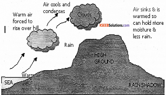
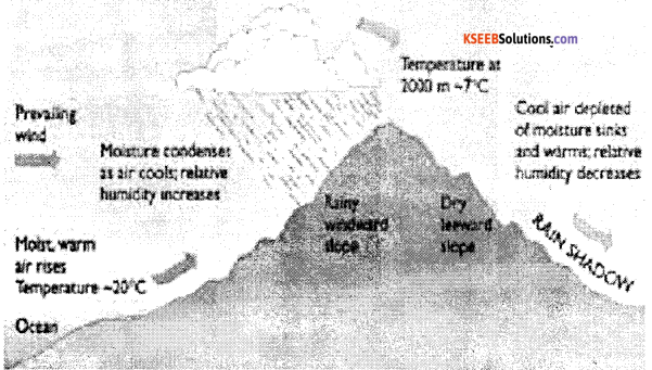
2. Orographic rainfall: When the moisture laden air from the sea is obstructed by a mountain, it is forced to move up the slope. As it moves up, it expands. Expansions lead to fall in temperature and the air cools. When the cooling takes places below the dew. point, condensation results and clouds are formed. When there is heavy condensation, the droplets of water in the clouds join to find bigger drops and there is rainfall.
Orographic rains are caused by the relief of the land. This type of rainfall is common in region where the mountain ranges are parallel and close to the sea and winds blow on shore. Behind the leeward side of the mountain, there is an area which receives very little rainfall and is called the rain shadow. Orographic rain is important in the monsoon land in summer, when the wind blows from the sea to the land. Thunderstorms also accompany this type of rainfall. It may be noted that the bulk of rainfall received by most parts of the world is of this type.
3. Cyclonic rainfall: The cyclonic rainfall is most common in the temperate region. The rainfall caused with a cyclone or depression is known as cyclonic rainfall. The winds take a circular movement in the regions where warm and cold air masses meet.
Question 28.
Explain the topography of the ocean floor.
Answer:
On the basis of the depth, the ocean floor can be divided into four zones, parts or relief features. They are.
1. The continental Shelf: The gently sloping portion of the continent or land that lies submerged below other sea is called the continental shelf. The continental shelf has a very gentle slope. It extends form the shore line to depths between 180 and 200 meters. Average width of the continental shelves is about 48km. The extent of the continental shelf depends on the relief of the broadening land masses.
If the coastal area is a plateau area, the continental shelf will be very broad. On the other hand, if the coastal region is hilly or mountainous, the continental shelf will be very narrow or even absent for example the Atlantic Ocean has 2.3%, the Pacific Ocean has 5.7% and the India Ocean has 4.2%.
2. The continental slope: The zone of steep slope that descends from the edge of the continental shelf to the deep sea plains is called “continental slope”. It is the transitional zone lying between the continental shelf and the deep sea plains. The continental slope is very steep. It extends from 182 meters to 3.600 meters. The angle of the continental slope is 2 to 5 degre3es or even more. It occupies only 8.5% of the total area of the ocean floor. But it varies from ocean to ocean. The Atlantic Ocean has broader continental slopes and accounts for 12.4%. But it is 7% of the Pacific Ocean and 6.5% of the Indian Ocean.
3. The deep sea plains: The level and rolling areas of the ocean floor are generally called deep sea plains or abyssal plains or the ocean plains. They lie between 3,000 and 6,000 meters below other surface of the ocean. They occupy vast area of the ocean floor and account for about 82.7% of the total sea floor. They cover about 90% in the Indian Ocean. Their depth ranges from 5,000 to 6,000 meters. They are covered by ozones, which are the remains of deep sea creatures and plants, and of red volcanic dust.
4. The Ocean Deeps: The long narrow and deep troughs on the ocean floor are known as ‘ocean deep’ or ‘trough’. They cover only 1% of the ocean floor. They are most common neat the coasts where young fold mountains, volcanoes and earthquakes abound. Some they are tectonic in origin. They are the deepest portions of the ocean. Deeps may be caused due to tectonic forces, i.e. faulting earthquakes etc. There are 57known deeps. of these 32 are found in Pacific Ocean, 19 in the Atlantic Ocean and 6 in the Indian Ocean. The deepest trench in the world is Challenger deep located in Mariana Trench to the west of Philippines in the North Pacific Ocean.
![]()
Question 29.
Briefly explain the Biomes.
Answer:
A distinct group of life forms and the environment in which they are found is called ‘Biomes’. In other words, Biome is a plant and animal community that covers a large geographical area. On the basis of the dominant life form, six major biomes are identified.
a. Forest biomes: Trees are the dominant life form of forest biome. High temperature, humid climate and soil moisture help for thick tree cover. Equatorial region is dominant with forest biome.
b. Savanna biome: It is the transitional biome between the forest biome and grassland biome. Savanna biome comprises of trees with grasses and herbs. It occupies areas of low and seasonal rainfall.
c. Grassland biome: in this biome grasses constitute the dominant vegetation. It is dominant in the moderate soil water deficit regions, semi-arid areas of dry tropical, sub-tropical and mid-latitude regions.
d. Desert biome: It includes organisms capable of surviving in moderate to severe water deficit for most of the year. In this region temperature may range from hot to cool. Most common plants found in this belt are xerophytes.
e. Tundra biome: It includes small plants that can grow quickly during a short warm to cool summer season, in the low temperature and high latitudinal areas.
f. Aquatic biome: Aquatic regions house numerous species of plants and animals, both large and small. This is where life began billions of years ago. Without water, most life forms would be unable to sustain themselves and the Earth would be a barren, desert-like place. Ponds, lakes, rivers, wetlands and oceans are sources of aquatic biomes.
Question 30.
Briefly explain the coastal plains of India.
Answer:
This is the region all along the Indian coastline, lying between the coast and the mountain ranges of the peninsular plateau. India has 6100 km from Gujarat in the west to West Bengal in the east. The average width is 10-25 kms. The coastal plain of India is divided into two parts.
The West Coastal plains: It is extends between the Arabian Sea and the Western Ghats. It is narrower than the east coastal plains, stretching to a length of about 1400km and width of 10 to 80km from the Rann of katchchh to Kanyakumari. The west coastal plains have Gujarat, Konkan, Karnataka and Malabar Coasts.
The Gujarat Coast comprises of Rann of Kachchh and Cambay coasts. It is formed by the alluvial deposits of Sabarmati, Mahi, Luni and other small streams. Gujarat has the longest coastline in India Kandla and okha are famous sea ports and along is the biggest ship breaking center. It produces highest salt in the country.
Konkan Coast lies to the south of Gujarat coast and extends line which provides suitable site for natural seaports. Eg: Mumbai, Navasheva, Marmagoa, Karwar, New Mangalore etc., this coast records highest coastal erosion. It is very rich in Petroleum and natural gas. Karnataka coast: it is a part of Konkan coast.
It extends from karwar in the north to Mangalore in the south. It is the narrowest part of west coastal plains. Karwar and New Mangalore are important ports in this belt. Sea Bird, the naval base near Karwar is the largest naval base in India.
The Malabar Coast extends from Mangalore to Kanyakumari, Sand dunes, lagoons and backwaters are the important features of this coast. Cochin or Kochi is the biggest seaport in this coast. Backwaters of Kerala facilitate navigation and tourists enjoy traveling though small country boats. The first south west monsoon rainfall is received in this coast.
East coastal Plains: It lies between the Ea’stern Ghats and the Bay of Bengal stretching from the delta of Hooghly in the North to Kanyakumari in the south. Compared to the west coastal plains the east coastal plains are broader.
The Tatkal Coast: It is the coastal plain of Orissa state. It extend for about 400kmms, north from Subarnarekha river to south of the Rushikulya river. It has a chilka lake, which is the largest salt water lake in India, Para deep is the important horbour located here.
Coromandel Coast: The southern part of east coast is known as the Coromandel Coast. It gets more rainfall from the north east monsoons and it is highly affected by cyclones. The oldest harbor Chennai located here.
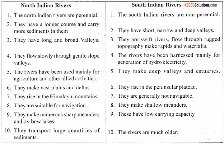
Question 31.
Compare the North Indian rivers with South Indian rivers.
Answer:
![]()
Question 32.
What is soil? Explain the major types of soil.
Answer:
Soil is the minute or finer rock particles found on the surface of the Earth. It is formed naturally, due to the weathering of rocks, under the influence of climate.
The main types of soil in India are:
1. Alluvial soil: This soil is formed by depositional work of rivers and they are mainly found in the flood plains and deltas. Alluvial soil covers largest geographical are in the country. They are mainly distributed in the river plains of the Ganga, Brahmaputra and the Indus. Uttar Pradesh has the largest area under alluvial soil. It is also found in the deltas of east flowing rivers. Alluvial soils are classified into two types.
- Bhangar: Older alluvium, coarse and pebble like in nature, found at the lower depths of the plain.
- Khadar: New alluvium, finer in nature, found in the low lying flood plains and rich in fertility
2. Black soil: The black soils covered more area in peninsular plateau. This soil is also called ‘Cotton soil’ or “Regur soil”. It is derived from the weathered basalt rocks. This soil holds water from long period and become hard whenever it is dry. It is light-black to dark-black in colour. Maharashtra and Gujarat Madhya Pradesh, Karnataka, Andhra Pradesh and Tamilnadu. Black soils are good for Cotton, Sugarcane, Tobacco, Pulses, Millets, Citrus fruits, etc.
3. Red soil: This soil is formed by the weathered granite rocks. It is red in colour and rich in ferrous content. Red soil covers the second largest area in the country. Largest parts of peninsular region are covered with red soil. TamilNadu has the largest distribution of this soil in the country. Rice, Ragi, Jowar, Groundnut, Tobacco, Millets are the major crops cultivated in this soil.
4. Laterite soil: The hot and humid tropical regions of India are rich in laterite soil. This soil is derived from the fragmentation and disintegration of rocks in the mountain ranges. It is mainly found in the Western Ghats, parts of Eastern Ghats and Northeastern hills of India. Plantation crops like Tea, coffee, Rubber, Cashew nut are cultivated in this soil.
5. Desert soil: This soil is also called arid soil. They are mainly found in the desert and semi-desert regions of Western and North western parts of India. This soil has the least water holding capacity and humus content. Generally it is not suitable for cultivation of crops. This soil is mainly found in Rajasthan, parts of Gujarat and Haryana. With water facility crops like Bajra, Pulses and Guar ar cultivated in this soil.
6. Mountain Soil: The Himalayan mountain valleys and hill slopes are covered with Mountain or Forest soil. It is found in the mountain slopes of Jammu and Kashmir, Himachal Pradesh, Uttarakhand regions, Crops like Tea, Almond, saffron are cultivated in this soil.
Question 33.
Briefly explain the importance of forests.
Answer:
Forests are the one of the important natural resources. They provide various benefits to mankind and environment.
The important benefits are:
- Forests supply fresh air, food and fodder.
- Forests are the rain bearers, help in causing good rainfall.
- They control soil erosion and desertification.
- Forest provides various products like bamboo, timber, resin, lac, gum cane, fuel, wood etc.
- They provide medicinal trees and plants used in ayurvedic medicines Eg.Neem tree. Basil, Brahmi etc.
- They provide shelter to various birds and animals.
- They absorb much of the rainwater and control floods and safeguards against drought.
- They act as wind breakers and protect the agricultural crops.
- The forest soils are rich in humus and thereby maintain the fertility of the soil.
- They provide raw materials to paper, match box, plywood and sports articles industries and they provide pastures for grazing animals.
Question 34.
Explain the Major seismic zones of India.
Answer:
Zone V: This is the most severe seismic (intensity above 7 in Richter scale) seismic zone and is referred as Very High Damage risk zone. The areas are. Northeastern states, parts of Jammu Kashmir, Uttarakhand, and Bihar and Kutch region.
Zone IV: This zone is second in severity (intensity between 5 and 7 in R.S) to zone VG. This is referred to as High Damage Risk zone. Northern regions of Jammu and Kashmir, Himachal Pradesh, Parts of Bihar, UP, Gujarat, West Bengal lie in this region zone. Northern regions of Jammu and Kashmir, Himachal Pradesh, parts of Bihar, UP, Gujarat, West Bengal.
Zone III: This is termed as Moderate Damage (very strong) Risk zone (intensity between 3 and 5 in R.S). The areas are Gujarat, Madya Pradesh, Rajasthan, Chhattisgarh, Odisha, Maharashtra, Northern Karnataka, Andhra Pradesh, West coastal region etc.
Zone II: This zone is referred to as low Damage (strong) Risk Zone (intensity 2 to 3 R.S). The areas are Rajasthan, Madhya Pradesh, Parts of Karnataka, Andhra Pradesh, Odisha etc.
Zone I: This zone is termed as Very Low Damage (Slight-tremor) Risk Zone. The left out parts of India and Deccan Plateau region.
![]()
IV. Answer any One of the following: (10 × 1 = 10)
Question 35.
What is rock? Describe the different types of rocks.
Answer:
Rock refers to the hard and resistant materials of the earth’s crust. But scientifically rock includes even soft and loose materials like chalk, clay, etc. So, rock refers to any solid materials, hard or soft of which the crust of the earth is formed. All rocks do not have the same chemical composition. But minerals have their own chemical compost in and physical prosperities. .The earth’s crust is made up of various types of rocks
Types of Rocks: Rocks can be classified into three major groups on the basis of their origin or mode of formation. They are:
A. Igneous rocks: The term Igneous is derived from the Latin word “Ignis”, means lire. Thus the igneous rocks are formed by the cooling and solidification of molten material which is called magma. Igneous rocks are also called primary rocks, because they were the firs to be formed. As they are the rocks from which all other types of rocks are derived, they are also called parent rocks.
Igneous rocks are commonly classified on the basis of mode of formation into two major types.
1. Intrusive rocks
2. Extrusive rocks.
1. Intrusive rocks: The magma cannot escape out to the earth’s surface, it cols slowly inside the earth’s crust and hardens into rock. This type of rock is known as Intrusive Igneous rock. E.g. Granite and dolerite. These rocks can be divided into two type’s a. Plutonic rocks and b. Hybabyssal rocks.
a. Plutonic rocks: The rocks which are formed due to cooling of magma at great depth inside the earth are called Plutonic igneous rocks.
b. Hybabyssal rocks: These are intermediate rocks between the extruded volcanic rocks and the deep plutonic rocks. They are formed due to cooling and solidification of magma in cracks, pores, crevices etc.
2. Extrusive rocks: Rocks formed by cooling and solidification of lava on the surface of the Earth is called extrusive igneous rocks. E.g. Basalt.
B. Sedimentary Rocks: These rocks which are formed due to aggregation and compactness
of sediments are known as sedimentary. In other words, sedimentary rocks are formed bye day the deposition of sediments derived form older rocks, planets and animals remains by river, winds, glaciers etc and these sediments are hardened into rocks by pressure. As they are formed by the consolidation of sediments. They are called sedimentary rocks. They are also called stratified rocks,
a. Mechanically-formed rocks: The rock which have been formed form the accumulation of rock materials, derived form other rocks and have been cemented together are known as “ Mechanically formed rocks.” The mechanically formed rocks consist of sediments which have been carried and deposited by rivers, glaciers, winds or waves and cemented together with clay or line. On the basis of rock materials. These rocks can be divided into three main categories. They are: Rudaceous rocks, Arernaceous rocks and Argilious rocks.
b. Chemically formed rocks: The chemical often settle down and hardened to form rocks known as chemically formed rocks. For example: Gypsum and rock salt, running water dissolves and carries chemicals and where evaporation takes place, these chemicals are deposited at the mouth of springs, caves or caverns or in lakes. Rock salt and gypsum are formed form deposit of salt in strata on the beds of lakes.
c. Organically formed rocks: Organic rocks are formed form the remains of organisms, i.e. of animals and plants. Examples: coal, limestone etc. On the basis of lime and carbon content, organically formed rocks can be divided into two kinds, namely.
(i) Calcareous rocks: Calcareous rocks are formed mostly from the remains of living organisms. These rocks contain calcium carbonate or lime. They include limestoneand chalk. They are porous and soluble.
(ii) Carbonaceous rocks: These are formed due to the transformation of vegetative matter. Under the impact of heat and pressure the remains of plants are turned into hard layers. E.g. coal.
C. Metamorphic rocks: Rock which has been changes either in form or in composition without disintegration is called metamorphic rocks. These rocks are metamorphosed from igneous sedimentary rocks. Igneous and sedimentary rocks may undergo chemical and physical changes because of pressure and heat and form metamorphic rocks. The intense heat and pressure in the earth’s curst alters the composition and appearance of rocks completely or partially to produce a new type of rocks. In this manner metamorphic. rocks are formed. Marble, Diamond, Quartzite, Ruby, Emerald are the examples of metamorphic rock.
![]()
Question 36.
Describe the land forms associated to work of river.
Answer:
River is an important external agent of denudation on the ever-changing face of the Earth. The work of river is more or less common in all the drainage systems of the world.
The work of river consists of three closely interrelated activities.
1. Erosional work: The process of wearing and taking away the part of rock is known as ‘Erosion’. It depends upon the volume and velocity of water, nature of slope and the nature of rocks. The erosional work of the river is performed in two ways.
a. The Mechanical and b. The Chemical erosion.
There are various Iandforms associated to erosional work of river.
a. ’V’ Shaped valley: In the mountain course the speed of the river is greater and volume is less. As the water rushes down the steep slopes there is maximum vertical , or later erosion. The rapid down cutting or vertical erosion results in the formation of ‘V’shaped valley.
b. Gorge: A deep and narrow valley with steep rocky, sides in the river course is known as ‘Gorge’. They are formed by the regular vertical cutting by the rivers in the valleys eg. Narmada gorge.
c. I shape valley: Avey steep, deep river valley formed by the river, lookinglike T, is called ‘I’ Shaped valley. These are very deep compared to gorges.
d. Canyon: It is a wide, deep and steep valley almost with vertical walls like feature found in the arid or semi arid regions is called ‘Canyon’ eg. Grand Canyon of River Colorado in USA.
e. Potholes: These are the small depressions in the rocky beds of other river valley. They are formed by corrosion. Pebbles, sand and small rocks carried by the river swirled around on the river bed. This action erodes the rock on the river bed forming potholes.
f. Waterfalls: Huge volume of water falling from a great height along the course of a river is called “Waterfalls’. They are formed when the hard and soft rocks come in the way of flowing river. The soft rock gets eroded faster and hard rock does not erode easily. Therefore huge amount of water falls from great height and creates waterfalls. Eg. The Jog falls, The Angel falls, The Victoria falls.
g. River Capture: It is formed mainly due to head-ward erosion by the river near its source. When the source of a river is captured by another major and strong river it is called‘River Capture’.
2. Transportational work: The process of carrying away the eroded materials is known as ‘Transportation’. The rock materials and eroded particles carried by a river is called its Load. The transportation capacity of a river is based on velocity of water, volume of water, load, slope, smooth valley floor etc.
The major landforms associated with the transportational work of the river are:
a. Alluvial fans: The term alluvium refers to the debris transported and deposited by rivers. When the fast flowing river enters the plateau or plain region, it experience sudden decline in gradient and obstruction in its path. Due to obstruction of the river spreads and deposits many of its light materials in fan shape known as ‘alluvial fans’.
b. Alluvial cones: In the plateau and foot hill region when the river spreads out, the eroded materials carried by the river is deposited in conical shape called ‘Alluvial cones’.
3. Depositional work: The process of carrying and accumulating the eroded materials by the river at the lower course is called ‘deposition’. In the lower course due to gentle slope the river slows down and deposits most of its materials on the banks, course and the mouth.
The important landforms resulting from depositional work of the river are:
a. Meanders: In the lower course, river flows slowly in zig zag or curved manner due . to smaller obstruction in its path. A curve or loop formed by the river in its path is called ‘Meander’. When the river course formed by such crescent shaped loops due to continuous lateral deposition it is called meandering course.
b. Ox-bow Lakes: The ox-bow lakes are formed by depositional and erosional actions taking place simultaneously and they are a result of excessive meandering. The River which flows through the shorter route leaving the curve of the meander cut off and crescent shaped lake is formed known as‘Ox-bow lakes’.
c. Flood Plains: When the river is in floods the water overflows on its bank and spreads in the surrounding regions. The silt carried by the water gets deposited in these areas and creates flat plains on both the banks of the rive known as ‘Flood Plains’.
d. Delta: A triangular shaped alluvial deposition forced at the mouth of the river is called ‘Delta’. Important types of deltas are
a. Arcuate or Common delta
b. Bird-foot delta
e. Distributaries: As the river approaches the sea or Ocean, due to reduction in gradient, joining of tributaries, its volume increases, speed decreases hence, the rivet begins to break up into a number of branches from the main river called ‘Distributaries’.
f. Estuary: Estuaries are the tidal mouth of a river having a narrow, gradually widening lay at the mouth. In Estuary River water is mixed with seawater. Eg. The Narmada estuary, The Kali estuary.
V. A. Answer the following questions in a sentence each: (1 × 5 = 5)
Question 37.
What is Cartography?
Answer:
The science and art of making maps, charts, globes is known as Cartography.
Question 38.
What is Scale?
Answer:
A scale is the ratio of the distance between two points on the map and their corresponding distance on the ground.
Question 39.
What is Index?
Answer:
The features shown on the map is indicated by a symbol which is called index.
Question 40.
Give an example for small scale map.
Answer:
Atlas and Wall maps.
Question 41.
What is latitudes?
Answer:
The imaginary lines drawn from east to west are called latitudes.
Question 42.
Mention any two uses of maps.
Answer:
- Maps are very useful to the government for planning and administrative purposes.
- They are very much helpful at the time of war and defence.
![]()
B. Identified the Latitudes and Longitudes for the given places in supplying Karnataka (1 × 5 = 5)
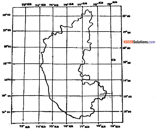
Question 43.
Bengaluru
Answer:
13° North (Latitudes)
Question 44.
Mysore
Answer:
12° 18′ North (Latitudes)
Question 45.
Mangalore
Answer:
12°51′ North (Latitudes)
Question 46.
Bellary
Answer:
15°09′ North (Latitudes)
Question 47.
Bidar
Answer:
17°54′ North (Latitudes)
C. Draw a diagram to the following: (2 × 2 = 4)
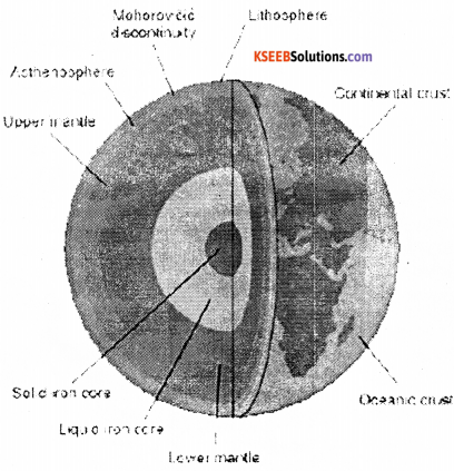
Question 48.
Layers of the Earth’s Interior.
Answer:
Layers of the Earth’s interior
Question 49.
Temperature of Heat Zones
Answer:
The Temperate zone: In between the Torrid and the frigid zones i.e., between 23 1/2°N and South and 66 1/2°N and S lies the Temperate Zone. In this zone the sun’s rays fall obliquely and hence the region experiences a moderate climate.
Question 50.
Orographic rainfall.
Answer:
Orographic rainfall
![]()
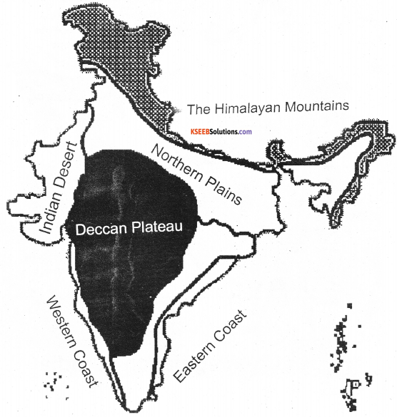
D. Draw the outline map of India, mark and name the following: (2 × 3= 6)
Question 51.
Map Drawing.
Physical divisions of India
Question 52.
South west and North east monsoon winds.
Answer:
Question 53.
Nligiri and cold desert biosphere reserves.
Answer:
Biosphere Reserves
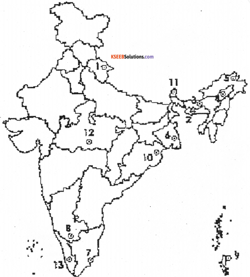
- Nanda Devi Saikhawa
- Nokrek
- Manas
- Dibru
- Dehang Debang
- Sunderbans
- Gulf of Mannar
- Nilgiri
- Great Nicobar
- Similipal
- Khanghendzonga
- Panchamarhi
- Agasthymalai
- Achanakmari – Amar Kantak
![]()
Blind Candidates only
Answer any three of the following: (5 × 3 = 15)
Question 54.
Explain the types of maps. 5
Answer:
Maps may be broadly divided into two types.
A. On the basis of Scale Maps are classified into three types.
(a) Large Scale Maps: The Maps drawn on the scale of 1 cm= 1 km or 1:1, 00,000 and 1 inch=1 mile or 1:63,360 eg. Cadastral maps (Village, Town and City maps).
(b) Medium Scale Maps: the Maps drawn on the scale of 1 cnm=1 Km to 1 cm=10 km or 1:1,00,000 and 1:10,00,000 eg. Topographical Maps (Mountains, Plateaus, plains).
(c) Small Scale maps: The Maps drawn on the scale below 1 cm: 15Km or 1:15,00,000 eg. Atlas and Wall Maps. These maps show broad physical and cultural features.
B. On the basis of purpose various types of Maps are prepared.
(i) Topographical maps: To show relief features, forests, land use, river system, roads, railways, pipelines, distribution of rural and urban settlements etc.
(ii) Cadastral maps: The Cadastral maps are drawn to register the ownership of field, farm, building, firm etc.
(iii) Economic Maps: These maps provide information about human economic activities eg. Agriculture, mining, industry, marketing, trade etc.
(iv) Population Maps: These maps show the information about distribution, growth, density, migration, age and sex composition of population. These maps are also drawn to show the distribution of occupational structure, language, social groups of people etc.
(v) Weather Maps: These are useful to analyzed weather condition and distribution of temperature, pressure, humidity, winds, rainfall etc.
Question 55.
Describe the size of the Earth. 5
Answer:
The ancient people made attempts to determine the size of the Earth. About 2,000 years ago a Greek astronomer, Eratosthenes, who lived In Alexandria in Egypt succeeded in calculating the size of the earth almost accurately, according to him, the earth’s circumference at the equator was 41,140kms. It was very close to the actual circumference of the earth, as known today.
The actual equatorial circumference of the earth is 40,076km, where as the polar circumference is 40,006km. The difference between the two is 70km. The earth’s equatorial diameter is 12,757km and the polar diameter is 12,714km. The difference is 43km. The geoids shape of the earth makes the circumference through the poles little less than that along the equator. The total surface area of the earth is 510. 9 million sq kms of the surface area, 71 % is covered by water mass and 29% is covered by landmass. The water mass is 361 million sq.kms and the land area is 149 million sq.kms. The land area is divided into seven continents and many island. The continents are Asia, Africa, and North America, South America, Antarctica, Europe and Australia.
The water area consist of five ocean, namely, the pacific Ocean, the Atlantic Ocean, the Indian Ocean, the Antarctic ocean and the Arctic Ocean and many gulfs, bays and seas. The globe is divided into two hemispheres, namely the northern hemisphere and the southern hemisphere, by the equator. The northern hemisphere contains 2/3 of the land and the southern hemisphere contains 1/3 of the land. The zero degree meridians decide the globe into two hemispheres, namely, the eastern hemisphere and the western hemisphere.
56.
Explain the temperature zones. 5
Answer:
Due to the Earth’s inclination at 66 1/2°and revolution, we recognize a few special latitudes on the globe. The vertical rays of the Sun strike the Earth at different points at different times of the year. On March 21st and September 23rd it falls on the middle of the Earth i.e., Equator. On June 21st the vertical rays fall on 23 1/2° North – Tropic of Cancer and on December 22nd it falls on 23 1/2° South- Tropic of Capricorn. On June 21st the Sun’s rays reach 66 1/2° South Antarctic circle. The North Pole (90° south) is the two ends of the Earth’s axis.
On the basis of special latitudes the globe may be divided into ‘Temperature zones’ or ‘ Heat zones’. Direct rays of the sun produce more heat than the slanting rays. The region near the equator receives more direct rays of the Sun. These rays are intense over smaller areas and so it heats up the Earth more. As we go away from the equator, the sun’s rays strike the Earth’s surface with slanting rays, spreading over a larger area so, they do not heat as intensely as the direct rays. Therefore, when we go from the equator to the poles, we come across zones with varying temperatures.
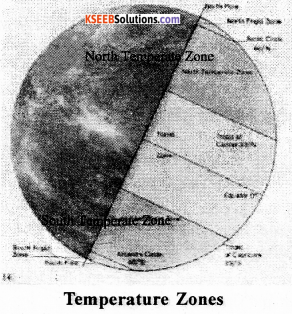
The Torrid Zone The zone stretches between 231/2°N and south latitudes and more or less receives the vertical rays of the sun. As a result, this region experiences moderately warm climate throughout the year.
The Temperate zone: In between the Torrid and the frigid zones i.e., between 23 1/2°N and South and 66 1/2°N and S lies the Temperate Zone. In this zone the sun’s rays fall obliquely and hence the region experiences a moderate climate.
The Frigid Zone: This zone extends from Arctic Circle to North Pole (66 1/2°N to 90°N) in the Northern Hemisphere and the Antarctic circle to South Pole (66 1/2° S to 90° S) is known as ‘Frigid Zone’. Since the sun’s rays fall extremely obliquely in this region, the region experience extremely cold climate.
![]()
57.
What is a mineral? Explain the types of minerals. 5
Answer:
Mineral is a natural inorganic substance which has certain chemical and physical properties. The scientific study of minerals is called Mineralogy. Minerals are used by man for various human activities. Understanding them minerals their types and uses is very important as natural resources of the earth.
Types: Minerals are classified into different types on the basis of nature, texture, and sues. Important among them are,
- Metallic Minerals: These minerals are not in metallic form and they do not contain metal. A few non-metallic minerals are Mica, Asbestos, Sulphur, lead, Zinc, Phosphate etc.
- Non-Metallic Minerals: These minerals are not in metallic form and they do not contain metal. A few non-metallic minerals are Mica, Asbestos, Sulphur, Lead, Zinc, Phosphate etc.
Minerals are also classified into other types.
Ferrous minerals which contain Iron e.g. Iron Ore. Non-ferrous minerals – these minerals do not contain ferrous e.g. Bauxite, Mica. – A few minerals are used for making decorative, commercial and precious ornaments are called Precious minerals. E.g. Platinum, Diamond, Gold and Silver. Some minerals are use for the generation of energy. They are Nuclear or atomic minerals e.g. Uranium, Thorium etc.